The Ha Giang Loop is not simply a scenic drive with a checklist of viewpoints. It is a demanding mountain journey through limestone valleys, high passes, small towns, and communities whose daily life continues alongside the road. A good plan leaves room for weather, slow climbs, market visits, fuel stops, and the occasional change of route. This four-day Ha Giang Loop itinerary is designed to help independent travelers make sensible decisions before they set off.
The route below follows the classic circuit through Quan Ba, Yen Minh, Dong Van, and Meo Vac, while treating safety and local respect as part of the experience rather than an afterthought. For a wider overview of the destination, see our thoughtful guide to Ha Giang by road, then use this article to shape the practical details.
What makes the Ha Giang Loop different
Ha Giang is about 300 kilometres north of Hanoi and is reached by road. Vietnam’s official tourism site describes the province as a destination for natural adventure and cultural exploration, with accommodation concentrated in places such as Ha Giang City, Dong Van, and Meo Vac. The route crosses the Dong Van Karst Plateau, recognized as Vietnam’s first UNESCO Global Geopark, and passes through a landscape of steep limestone formations, deep valleys, and winding mountain roads.
That geography explains why distances can be misleading. A map may show only a short connection between two towns, but a mountain road with tight bends, steep gradients, road works, livestock, and frequent viewpoints can turn a modest distance into most of a day. The best Ha Giang Loop itinerary is therefore built around daylight and energy, not around covering the maximum number of kilometres.
Expect a journey with several layers: dramatic scenery, local markets, H’Mong and other ethnic minority communities, historic houses, and long stretches where services are limited. If you want more background on choosing an adventure that fits your experience and group, browse the Outdoor Adventure Activities category before deciding how ambitious your route should be.
Before you leave Ha Giang City
Choose the right way to travel
The loop is commonly associated with motorbikes, but riding it yourself is not the only option. A confident, properly licensed rider with experience on mountain roads may prefer an independent trip. Travelers who are inexperienced, carrying a passenger, or uncomfortable with steep curves should consider a reputable guided tour or a local driver. Do not treat the loop as a place to learn basic motorbike control.
Ask rental providers or tour operators clear questions before accepting a bike: what documents and insurance are included, how roadside assistance works, whether a helmet is provided, and what happens if the weather makes a section unsafe. Vietnam Tourism notes that motorbikes can be rented in Ha Giang City and that service centres are available there, but availability and terms can change, so confirm current details locally rather than relying on an old social-media post.
Pack for changing conditions
Bring a secure rain layer, warm clothing for exposed passes, gloves, closed shoes, sun protection, a small first-aid kit, and a dry bag for electronics. Carry enough drinking water and some cash. The official four-day route guide warns that ATMs become scarce outside Ha Giang, so do not assume every overnight stop or fuel station will accept a card. Keep your passport and important documents protected from rain, and store an offline copy of your accommodation details.
Download an offline map, but use it as a support rather than an authority. A road may appear open on a map while a landslide, construction project, fog bank, or local diversion changes the practical situation. Ask your host about the next day’s road conditions before setting out.
A practical four-day Ha Giang Loop itinerary
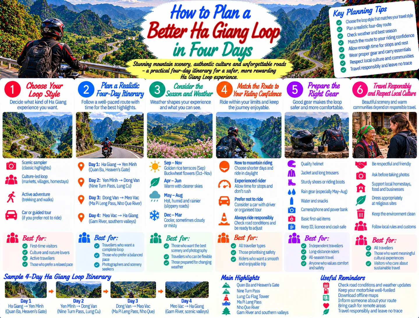
Day 1: Ha Giang City to Quan Ba and Yen Minh
Leave Ha Giang City early enough to ride in daylight without rushing. The first major section follows QL4C toward Quan Ba and Heaven’s Gate Pass. The road quickly changes from urban edges to limestone mountains, forested slopes, and open viewpoints. Quan Ba’s twin mountains and the surrounding valley make a natural first pause, but avoid turning every viewpoint into a long stop if the weather is deteriorating.
Continue toward Tam Son for food, fuel, and a realistic check of your pace. From there, the road leads toward Yen Minh through passes and valleys. The official tourism itinerary describes the route as following the Mien River before climbing through a canyon and karst landscape. This is a useful first-day rhythm: a steady morning, a proper midday break, and an afternoon arrival before darkness.
Stay in or near Yen Minh and ask your host about the next day’s conditions. If you arrive late, resist the temptation to continue simply because Dong Van is still on the map. A short first day with energy left is safer and more enjoyable than a rushed arrival on unfamiliar roads.
Day 2: Yen Minh to Dong Van, with optional Lung Cu
Day two brings more exposed karst scenery and several memorable passes. From Yen Minh, continue toward Dong Van, stopping in the Sa Phin area for food and fuel. The Nine Turn Pass is a natural place to pause, but park well away from the road and never stand in a blind bend for photographs.
One decision is whether to add Lung Cu Flag Tower. The official four-day route describes this as a substantial detour and recommends allowing several hours. Include it only if the weather is clear, your riding pace has been comfortable, and you still have enough daylight. Otherwise, make Dong Van your priority. An optional viewpoint should never turn a manageable day into a night ride.
Dong Van is a good base for a slower evening. Walk through town, eat locally, and ask your host about market dates and times. Markets are not staged performances; they are working community spaces. Observe before taking photographs, ask permission for close portraits, and avoid blocking entrances or trading areas.
Day 3: Dong Van to Meo Vac over Ma Pi Leng Pass
This is often the visual high point of the loop. The road from Dong Van toward Meo Vac crosses the dramatic Ma Pi Leng Pass, with steep slopes and expansive views toward the Nho Que River. Vietnam Tourism describes the Dong Van-to-Meo Vac section as short in distance but slow in practice because travelers stop repeatedly to take in the scenery.
Build that slowness into your plan. Keep your eyes on the road while riding, and use designated pull-offs or broad safe areas for photographs. Wind, fog, wet pavement, and oncoming traffic can change the character of a pass quickly. If conditions are poor, a viewpoint missed today is less important than arriving safely.
After Meo Vac, choose your overnight stop according to weather, energy, and confirmed accommodation. Some itineraries continue toward Bao Lam, while others return more directly or use a slower local route. A side road toward the Nho Que River can be rewarding, but ask locally about its condition and allow extra time. Do not add a detour simply because an online itinerary lists it as a quick ride.
Day 4: Return toward Ha Giang City
The return is not a formality. Plan fuel, food, and breaks before leaving. The official four-day route uses QL34 from Bao Lam toward Ha Giang, following the Gam River for parts of the journey and passing through Bac Me. Compared with the most dramatic passes, the road may feel gentler, but fatigue is now a serious factor.
Start early, take regular breaks, and leave a margin for road works or rain. If you are tired, shorten the day and arrange transport rather than riding after dark. Arriving back in Ha Giang City with time to spare is a successful ending, not wasted capacity.
How to ride the mountain roads more safely
Use a daylight-first approach
Daylight gives you better visibility around blind curves, animals, pedestrians, loose gravel, and unexpected vehicles. Set a turnaround time each afternoon. If you are not close to your overnight town by then, stop and reassess instead of allowing the itinerary to dictate your decisions.
- Slow before a curve, not while already leaning into it.
- Keep a generous distance from buses, trucks, and other motorbikes.
- Use the horn appropriately at blind bends, but never assume it makes you visible.
- Expect surface changes after rain, including mud, gravel, and standing water.
- Stop completely before checking a map or taking a photograph.
- Never carry on because another rider appears to be travelling faster.
Vietnam Tourism’s practical guidance says road conditions are generally good on the four-day route but that obstacles and construction can appear at any time. It specifically advises caution on curves, daytime driving, and stopping after dark. Those simple rules are more useful than trying to predict an exact average speed.
Know when to change the plan
Heavy rain, dense fog, a mechanical problem, illness, or an inexperienced rider in the group are all valid reasons to stop. Tell your accommodation host where you are going and listen when locals recommend a slower route. A flexible Ha Giang Loop itinerary should include at least one recovery option: an extra night, a shorter riding day, or a transfer back to Ha Giang City.
Staying in villages and traveling respectfully
Ha Giang’s appeal depends on more than scenery. Families run homestays, farmers work the valleys, and markets serve local communities. Choose accommodation that explains its services clearly and follow household rules about shoes, meals, quiet hours, and shared spaces. Buy food and small necessities locally where practical, and pay fairly for services rather than bargaining aggressively over modest amounts.
Ask before photographing people, homes, ceremonies, or children. Do not enter a house, school, field, or religious space because it looks photogenic. Dress modestly away from resort-style accommodation, keep noise low, and take rubbish with you. These are not abstract principles: they make it easier for residents to welcome visitors without feeling that their everyday life has become a backdrop.
For broader guidance on responsible road travel in the region, read Planning a Northern Vietnam Road Trip Responsibly. You can also explore the site’s Motorbike & Road Trips category for related preparation ideas.
When to go and how to pace the trip
Ha Giang changes with the seasons. Vietnam Tourism highlights spring flowers, flooded terrace fields in summer, cooler autumn conditions, golden rice landscapes, and buckwheat flowers from roughly October to December. These seasonal descriptions are useful for choosing atmosphere, but they are not a promise of clear roads or identical weather each year.
Choose dates based on the experience you want, then check a current forecast and local road advice shortly before departure. In wet or cold conditions, shorten your riding days and allow extra time for viewpoints. In busy periods, reserve popular homestays ahead when possible. The official route guide notes that sought-after accommodation can sell out, particularly during peak season.
If the loop is your first serious mountain ride, four days is a sensible minimum rather than a target to compress. Adding a night can make the itinerary calmer, especially if you want to visit markets, walk in villages, or include Lung Cu without rushing. Travelers who prefer walking over long hours on a bike can pair the road trip with ideas from the site’s Mountain Trekking & Hiking category.
A final checklist for the morning you leave
- Confirm your bike, helmet, documents, and emergency contact.
- Check fuel, brakes, lights, tyres, mirrors, and luggage straps.
- Carry water, food for the next stretch, cash, rain protection, and warm layers.
- Ask your host about weather, road works, and a safe arrival time.
- Save your accommodation address and the next stop offline.
- Agree on a group riding order and meeting points.
- Leave enough time to stop before sunset rather than planning to arrive at the limit.
Conclusion
The best Ha Giang Loop itinerary is not the one with the most stops. It is the one that matches your riding ability, leaves room for mountain conditions, and gives you time to notice the people and places along the road. Use the four-day outline as a framework, keep every day flexible, and treat safety, local advice, and respectful travel as essential parts of the adventure. That approach will help you return with stronger memories and fewer unnecessary risks.
JOIN THE CONVERSATION
Comments (0)
No comments yet. Be the first to share a thought.