A Ha Giang loop itinerary is more than a list of viewpoints. It is a plan for moving through a remote mountain region where weather, road conditions, daylight and local events can change the shape of a day. The best trips leave room for slower riding, unplanned viewpoints and conversations in small towns. This guide explains how to build a realistic route, decide whether to ride independently, and prepare for the practical details that make the loop safer and more rewarding.
Start with the right kind of Ha Giang loop itinerary
Most travellers begin in Ha Giang City and travel north towards the limestone mountains before returning by a different road. The classic circuit connects places such as Quan Ba, Yen Minh, Dong Van, Meo Vac and Du Gia, but there is no single correct version. Your route should reflect your riding experience, arrival time, weather forecast and appetite for long mountain days.
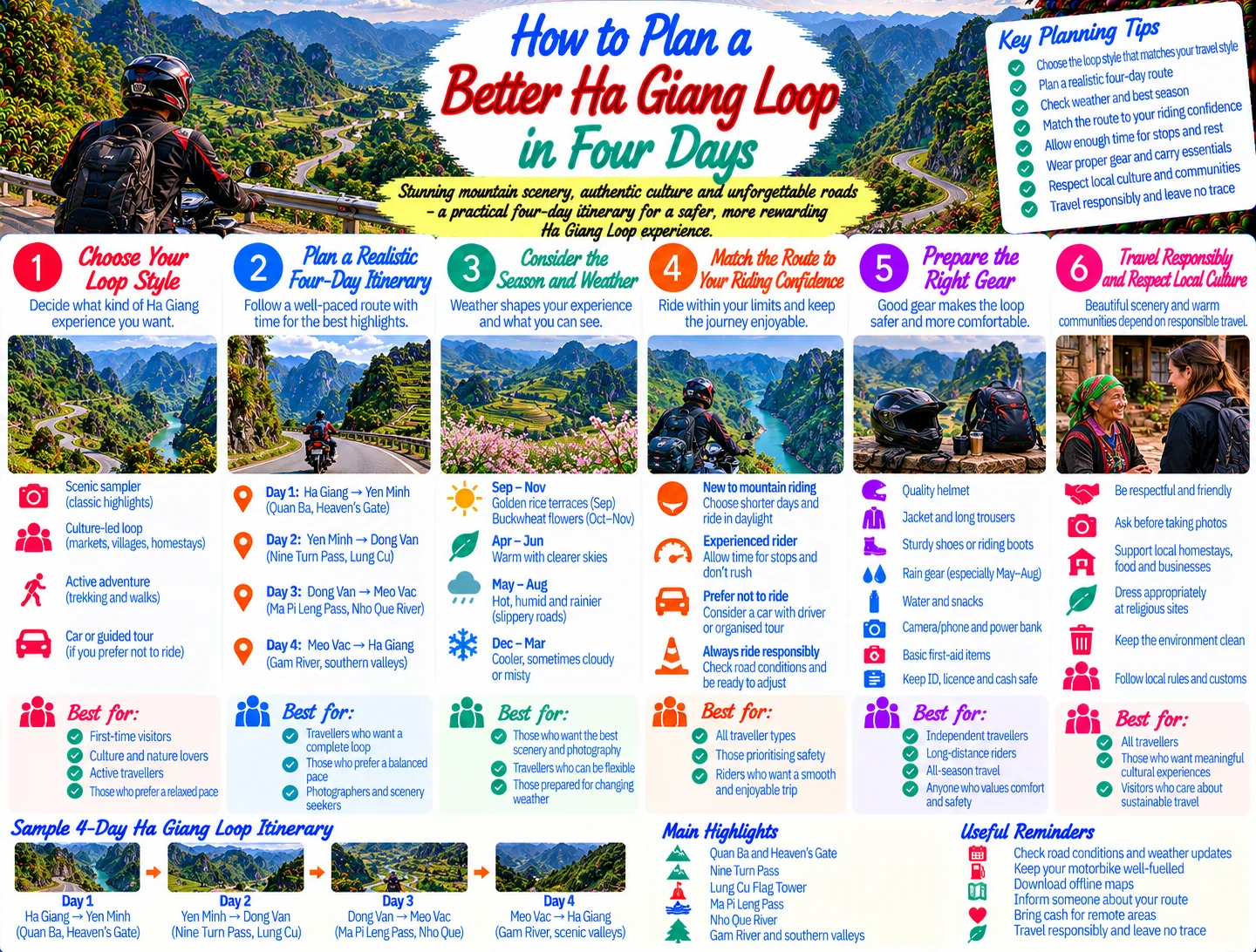
Vietnam’s official tourism guidance describes Ha Giang as a road-trip destination and outlines a four-day route through the northern mountains. That is a useful framework, but it should not be treated as a race. A four-day plan can work for confident riders who start early and accept long days. Five days gives more breathing room for photographs, market visits, short walks and delays. Six days or more is better if you want to combine the main loop with quieter villages or a trek.
- Three days: possible only with a tightly edited route and little margin for weather or mechanical delays.
- Four days: a practical first outline for strong riders, provided each day is planned around daylight.
- Five to six days: the more comfortable choice for first-time mountain riders and travellers who want village time.
Before booking accommodation, decide what matters most: dramatic passes, ethnic minority markets, walking, photography, food or simply the feeling of being in the mountains. That priority will help you avoid an itinerary that looks impressive on a map but feels exhausting on the road.
Choose your transport and riding style
Independent riding
Independent riding offers the most flexibility. You can stop when clouds lift over a valley, change your overnight town or take a short detour without coordinating a group. It also requires honest self-assessment. The loop includes steep, winding roads, changing surfaces, trucks, local traffic and sections where help may not be immediately available. A rider who is comfortable on a scooter in a city is not automatically ready for several consecutive days of mountain roads.
If you ride independently, use a properly maintained bike, wear a helmet that fits securely, carry basic rain protection and keep your phone protected from water. Practise controlled braking and slow cornering before leaving Ha Giang City. Do not plan to ride after dark: visibility, road hazards and fatigue make an already demanding route less forgiving.
Guided trips and easy-rider arrangements
A guided trip or easy-rider arrangement can reduce navigation stress and let you focus on scenery. It may also suit travellers who do not have the confidence, licence or experience to ride the route themselves. Ask exactly what is included before committing: accommodation standard, passenger numbers, luggage arrangements, meal expectations, riding hours and the plan if rain or road work changes the route.
For broader preparation, read Planning a Northern Vietnam Road Trip Responsibly. The same principles apply here: choose a pace you can sustain, avoid treating roads as a test of bravery and spend money with local businesses where possible.
Build the route around manageable riding days
Day one: Ha Giang City to Quan Ba or Yen Minh
The first day is about settling into the landscape. As the road climbs away from Ha Giang City, the scenery changes quickly from settled valleys to limestone hills and high passes. Quan Ba is a sensible early overnight if you arrive late or want time for viewpoints and a short walk. Yen Minh works for travellers who start early and want to position themselves farther north.
Do not measure this day only by kilometres. Mountain roads take longer than a flat map suggests, and repeated stops are part of the experience. Leave time for fuel, food, weather layers and a careful approach to bends. If you feel rushed on the first day, shorten the next section rather than trying to recover time at higher speeds.
Day two: Yen Minh, Sa Phin and Dong Van
The road towards Dong Van passes through dramatic karst scenery and several places where a short stop adds context to the landscape. Sa Phin is associated with the former H’Mong King Palace, while the route towards Lung Cu offers a borderland perspective and a demanding detour. Vietnam Tourism notes that reaching Lung Cu involves a climb of around 200 steps to the flag tower, so allow time and energy if you include it.
Dong Van is a useful overnight base because it gives you a chance to walk rather than immediately returning to the bike. Ask your host about local market dates instead of assuming that a market takes place every day. Market days can be excellent cultural experiences, but visitors should observe without blocking stalls, photographing people without consent or treating ordinary commerce as a performance.
Day three: Dong Van, Ma Pi Leng Pass and Meo Vac
This is often the visual highlight of a Ha Giang motorbike route. The road over Ma Pi Leng Pass follows exposed mountain terrain with deep valleys and wide views. It deserves a slow pace. Pull fully off the road where possible, keep away from unprotected edges and never stop in a blind corner just to capture a photograph.
Meo Vac is close to Dong Van on the map, but viewpoints and traffic make the journey longer than the distance suggests. If you want to see the Nho Que River more closely, treat the descent as a separate activity rather than squeezing it into an already full riding day. A flexible itinerary can leave the pass, river and town as three different experiences instead of trying to collect them quickly.
Day four and beyond: Du Gia or a slower return
From the northern section, many travellers continue towards Du Gia before returning to Ha Giang City. This creates a different rhythm: smaller roads, greener valleys and more time around homestays. Others return through a longer western or southern route. Choose based on current local advice, road conditions and your remaining daylight rather than following a route simply because it appears on a popular map.
For a general framework on matching an outdoor plan to your group, see Choosing an Outdoor Adventure That Suits Your Group. It is especially useful when one person wants long riding days and another would prefer walks, cafés and village time.
Prepare for weather, roads and logistics
Ha Giang has a cool mountain climate, and conditions can change quickly with altitude. Vietnam Tourism identifies September to November as a particularly attractive period, with golden rice terraces in September and buckwheat flowers commonly associated with October and November. It also warns that roads can be wet and slippery from May to August. These are useful seasonal signals, not guarantees; check the forecast shortly before departure and ask local hosts about conditions on the exact roads you plan to use.
Pack for change rather than for one perfect photograph:
- Light layers that can be added or removed during climbs and descents.
- A waterproof outer layer for both rider and luggage.
- Gloves with enough grip for cooler, wet conditions.
- Sun protection, water and snacks for stretches between towns.
- Offline map access and a power bank, while remembering that signal can be inconsistent.
- Small cash reserves, because official route guidance notes that ATMs become scarce outside larger towns.
Fuel up whenever you have a reliable opportunity, especially before a remote section. Keep your documents and essential medication in a dry pouch. If a bike develops a problem, stop early and ask a reputable local mechanic or your rental provider for help. Continuing with a loose brake, damaged tyre or unreliable light can turn a minor inconvenience into a serious risk.
For a wider approach to responsible mountain travel, A Safer, More Enjoyable Day on a Mountain Trail covers pacing, preparation and respect for changing outdoor conditions.
Make the cultural side part of the route
The most memorable Ha Giang experiences often happen away from the highest viewpoint. Stay in a locally run homestay when it suits your comfort level, eat in family restaurants and buy snacks or handicrafts directly from small businesses. Learn a few polite Vietnamese phrases, ask before entering private spaces and follow the lead of hosts when visiting villages or markets.
Do not assume that traditional clothing, homes or ceremonies are public attractions. Ask before taking photographs, especially of children and older residents. Avoid handing sweets or money directly to children. If you want to support a community, choose a fair purchase, a locally guided walk or accommodation that clearly employs people from the area.
Keep the landscape quiet and clean. Take rubbish with you, avoid loud music at viewpoints and do not climb fragile roadside formations for a better angle. The region’s appeal depends on both its geology and its living communities, so responsible behaviour is not an optional extra to the itinerary.
Our National Parks & Wildlife category offers more ideas for travelling through northern landscapes with care, while Motorbike & Road Trips is a useful place to compare route-planning approaches before you set off.
Use a flexible daily checklist
A simple routine can prevent small problems from multiplying. Before leaving each morning, check the weather, fuel, brakes, tyres, lights and luggage straps. Confirm the intended overnight stop, then identify one backup town in case rain or fatigue changes the plan. Tell your accommodation host roughly when you expect to arrive, especially if you are travelling on a quieter road.
During the day, stop before you become tired rather than after. Drink regularly, eat before you are hungry and take a proper break after a difficult pass. If visibility drops, wait it out somewhere safe. If the road surface looks damaged, slow down and give yourself room to react. A flexible itinerary is not a failed itinerary; it is the correct response to mountain travel.
At night, review the next day without overloading it. Mark the places you genuinely want to see, then leave open space around them. This approach protects the parts of the trip that cannot be planned: a clear view after rain, a welcoming meal, a local market, or a quiet road through the hills.
When to change or cancel a riding day
Some decisions should be easy. Postpone riding if you are ill, severely fatigued, inexperienced for the conditions or unable to see the road clearly. Heavy rain can make surfaces slick and obscure corners; fog can remove the visual information you need to judge a bend. Ask local accommodation staff or your rental provider for current advice, but make the final decision conservatively.
You can still use a weather day well. Walk around town, visit a market if one is operating, learn about local food, rest or arrange a shorter transfer. The goal of a Ha Giang loop itinerary is not to prove that every planned kilometre was completed. It is to return with good memories and enough energy to appreciate the places you visited.
Conclusion: plan the backbone, leave room for the mountains
The strongest Ha Giang loop itinerary has a clear backbone but remains adjustable. Choose the right transport, allow more time than a flat map suggests, ride only in conditions you can manage and build your route around daylight. Balance famous passes with villages, food and rest, and treat local communities and the landscape as part of the destination rather than scenery outside the road. With that approach, the loop becomes less about ticking off viewpoints and more about travelling attentively through one of northern Vietnam’s most remarkable regions.
JOIN THE CONVERSATION
Comments (0)
No comments yet. Be the first to share a thought.